Thanks to a Little-Known Treaty, Poorer Countries Can Now Say No to Exported Waste

Poorer countries can now refuse shipments of plastic waste and slow the build-up of pollution on their shores.

The world generated 242 million tonnes of plastic waste in 2016 – a figure that’s expected to grow by 70% in the next 30 years. But this same plastic is also a commodity that’s sold and traded in a global industry that generates $200 billion every year.

Exporting plastic waste is one way rich countries dispose of their waste. By selling waste to firms that then send it to countries where recycling costs are cheaper, rich countries can avoid the unpleasant task of finding somewhere at home to dispose of it. Unfortunately, most of this waste is shipped to countries that aren’t equipped to properly manage it.

When wealthy countries export their plastic waste to poorer countries with weaker recycling capacity, those plastics are often dumped, eventually polluting the land and sea. But a recent UN decision could help those countries most affected by plastic litter and with the least capacity to manage it. Due to a little-known treaty called the Basel Convention, poorer countries can now say no to the deluge of exported waste.
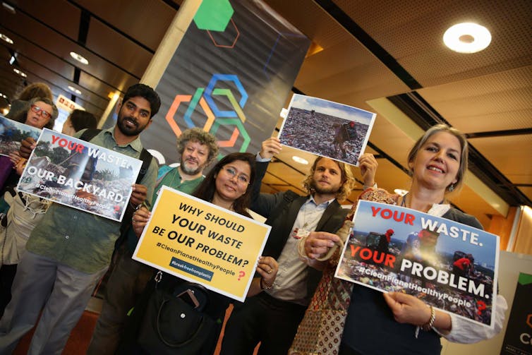
Activists urge progress at the Basel Convention. Photo: IISD/ENB | Kiara Worth, Author provided

An enduring injustice

The Basel Convention was adopted by the UN in 1989 to manage the flow of toxic waste sent from rich to poor countries. It’s cheaper for wealthy countries to relocate their waste to areas with lower costs and oversight, and so opportunities to abuse the system emerge.

Italian waste management firms made headlines in 1988 because they stored hazardous wastes in a Nigerian fishing village, in drums labelled as building materials. For years Canada delayed repatriating waste – including nappies – dumped by a Canadian firm in the Philippines. The refuse has been sitting in the sun there since 2013.

The images of plastic waste piling up on beaches in many developing countries, including on some of the world’s most remote islands, prompted an effort led by Norway to use the Basel Convention for its original purpose.
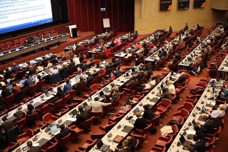
Delegates negotiate the text to determine which plastics will be regulated by the UN decision. Photo: IISD/ENB | Kiara Worth, Author provided

The negotiations held in Geneva over two weeks were intended to bring urgent action to address a complex issue. A few countries, such as Argentina and the US, were more cautious, as exporters of plastic waste themselves. They, like the recycling industry, warned that regulations could make it more difficult to recycle plastic, at a time when much more needs to be recycled. Statements went on for hours as developing countries recounted the plastics littering their lands, seas, beaches and even glaciers.

Norway brought forward a proposal to change how the treaty regulates plastics, by moving many types of plastics from the “non-hazardous” category to a list of wastes “of special concern.”

Starting in 2020, this will require developing countries to be informed if these plastics are in a waste shipment. With this information, countries can give, or revoke, their “prior informed consent”. For the first time, developing countries can refuse a shipment of plastics with the backing of international law.

Making the recycling industry fairer

This decision only applies to low-value, hard-to-recycle plastics. Think of food packaging or single-use water bottles: the plastics are soiled or mixed together (the lid, label, and bottle are different types of plastic), making them difficult to recycle. Most recyclers don’t want these plastics, which don’t generate a profit and increasingly are dumped in the landfills of poor countries.

Also read: How Are India’s Plastic Waste Imports Increasing?

Research shows how cheap plastics leach persistent organic pollutants into the environment – a particularly nasty group of chemicals that are toxic, travel through air and water over long distances, accumulate in animal tissue (including humans), and last a long time. More than 233 marine species have ingested plastic and litter has reached the deepest parts of the ocean.

The trade in global plastics is one driver of this problem, so giving developing countries the right to know what is entering their country and to refuse it is an appropriate solution to waste dumping.

Contaminated and mixed material waste like coffee cups are difficult to recycle and more likely to end up in landfill. Photo: Robert Kneschke/Shutterstock

China, previously the world’s largest importer of plastics for recycling, banned the import of cheap and contaminated plastics in 2018, displacing plastic waste to other countries. China’s neighbours, such as Indonesia, and Malaysia, shouldered a heavier burden, particularly since countries like the UK continue to export over 600,000 tonnes of plastic a year.

Rich countries tend to produce the most plastic waste in the world per person and have better systems for managing it. If cheap and easy routes for dumping plastics close, wealthier countries may have to find ways to compel recycling companies to deal with their cheap plastics domestically.

This agreement is only the start, but it could empower poorer countries to refuse the deluge of plastics that ultimately end up lingering on their shores. In time, it may help redress some of the burning injustices in the global waste trade.

Jen Allan, Lecturer in Environmental Politics, Cardiff University

This article is republished from The Conversation under a Creative Commons license. Read the original article.

Bushfires Sweep Across Southeast Australia, 2 More Killed

By late afternoon, Victoria had 17 fires rated at emergency or evacuate warning levels and New South Wales had 12 rated emergency, with more than 100 others burning across the states.

Sydney: Bushfires burned dangerously out of control on Australia’s east coast on Saturday, fuelled by soaring temperatures and strong winds that had firefighters battling to save lives and property, and authorities said the worst of conditions was yet to come.

By late afternoon, Victoria had 17 fires rated at emergency or evacuate warning levels and New South Wales had 12 rated emergency, with more than 100 others burning across the states.

“We are in for a long night and we are still to hit the worst of it,” NSW Premier Gladys Berejiklian said at an afternoon briefing. “It’s a very volatile situation.”

Authorities have said conditions could turn out to be worse than New Year’s Eve, when fires burnt massive tracts of bushland and forced thousands of residents and summer holidaymakers to seek refuge on beaches.

As the NSW Rural Fire Service (RFS) updated its emergency warnings on the fires, it repeatedly delivered the same blunt advice to those who had not evacuated at-risk areas: “It is too late to leave. Seek shelter as the fire approaches.”
One fire in southern NSW was generating its own thunderstorm, the RFS said, which created new dangers as lightning strikes could set off new fires.

As the fires worsened, residents used social media to post photos of the sky turning black and red from the smoke and glare of the fires, including in the Victorian town of Mallacoota, where around 1,000 people were evacuated by sea on Friday.
The federal government announced an unprecedented call up of army reservists to support firefighters as well other resources including a third navy ship equipped for disaster and humanitarian relief.

Andy Gillham, the incident controller in the Victorian town of Bairnsdale, said the area had avoided the worst of the fires on Saturday but stressed this was an exceptional fire season.

“In a normal year, we would start to see the fire season kick off in a big way around early January and we’re already up towards a million hectares of burnt country. This is a marathon event and we expect to be busy managing these fires for at least the next eight weeks,” he said.

Following are highlights of what is happening across Australia:

– Temperatures topped 45C (113F) in much of the Sydney metropolitan area, with Penrith recording a high of 48.9C (120F) according to the Bureau of Meteorology. Canberra, the national capital, recorded a temperature of 44C just after 4 pm, which the chief minister said was a record for the territory.

– A late southerly wind change expected on Saturday will dramatically lower temperatures, but it will also bring wind gusts of 70-80 kmh (43-50 mph) that are likely to fan the strength and unpredictability of fires that have already isolated towns, with major roads and highways being closed.

– In South Australia, two people died on Kangaroo Island, a popular holiday spot not far off the coast, taking the national toll from this week’s fires to 12. Twenty-one people remain unaccounted for in Victoria, down from 28 reported on Friday.

– South Australian Premier Steven Marshall said more than 100,000 hectares of Kangaroo Island, about one quarter of its total area, had been burnt, but weather conditions have now improved after Friday’s fires.

– The first of thousands of residents and vacationers stranded on a beach in Mallacoota in southeastern Australia landed near Melbourne on Saturday morning after a 20-hour journey by ship. A much bigger ship, carrying about 1,000 people, is due to arrive on Saturday afternoon.

– The focus on Saturday is preventing more loss of life, authorities said. National parks have been closed and people urged earlier this week to evacuate large parts of NSW’s south coast and Victoria’s north eastern regions, magnets for holidaymakers at the peak of Australia’s summer school holidays.

– National death toll in current fire season, which began in September, is 23, Prime Minister Scott Morrison said.

– Morrison confirmed that his visit to India and Japan scheduled for mid-January had been postponed due to the fires.

– More than 5.25 million hectares (13 million acres) of land has been burnt this fire season.

(Reuters)

Welcome to Antarctica’s First Research Station Powered by Green Energy

The station proves that sustainable living is possible anywhere.

As a scientist investigating climate change, I’m embarrassed by the high carbon footprint I have when I travel to, and work in, Antarctica. Researchers based in the UK regularly take four or five flights to reach the continent and the stations we visit rely on electricity from fossil fuels. Our food is shipped in and our waste is returned by ship to South Africa, South America or New Zealand. When we venture further afield for research and set up a temporary camp, a portable generator is flown in with us, along with our snowmobiles.

Antarctica is the most remote and inhospitable place on Earth, so it’s no surprise that people based there have struggled to break out of convenient habits. It’s cold. There are 24 hours of darkness in winter. Icicles build up on solar panels operating during the summer months and the concrete foundations for wind turbines won’t set in the cold. It’s expensive to ship in renewable energy components and it’s difficult to find warm and dry places to keep large batteries for storing energy.

These challenges are real, and yet, I’ve seen how they can be overcome at Antarctica’s only zero-emission research base, the Princess Elisabeth Antarctica Research Station in East Antarctica. The base is staffed during the summer season from October to March, when the majority of scientists – like me – conduct their research.

Take the tour

Dreamt up by the Belgian explorer Alain Hubert during his transantarctic crossing of the continent by kite ski in 1998, and constructed by the International Polar Foundation and its many partners, the Princess Elisabeth station has welcomed researchers since its first 2008-2009 summer research season.

The glinting silver pod looks like something from a James Bond film. It’s anchored by raised pylons, hovering above the East Antarctic Ice Sheet on a narrow granite ridge. In Antarctica these other-worldly structures are somewhat the norm. Raised, aerodynamic research stations litter the edge of the continent, where researchers from around the world gather to measure ice flows, the atmosphere and natural biomes.

While these stations all have similar traits, the Princess Elisabeth stands out. I have never seen anything like it. Almost every inch is covered in solar panels – on the roof, on the walls, on the side of sleeping containers. They are even screwed to frames anchored to the ground.

Also Read: ‘Climate Emergency’ Is Oxford Dictionary’s Word of the Year for 2019

Solar panels have to be mounted high above the snow-covered ground to capture the 24 hours of daylight during the austral summer. Wind turbines are drilled into the granite ridge beneath the snow and ice, removing the need for large concrete foundations. Their blades are maintained with carefully designed polar lubricants, but they can shut down production during intense storms. These renewable energy sources melt snow for water, which is filtered and reused on site to reduce waste.

The whirl of nine wind turbines generates the reassuring sound of regular clean electricity on base. While other research stations have to use fossil fuels to keep station staff warm, fed and hydrated, the Princess Elisabeth station uses 100% renewable energy supplied by the sun, the wind, and plentiful frozen water.

There’s no need for conventional heating here either. Nine layers of cladding and insulation keep the biting Antarctic cold out, and the pleasant warmth of the station in. Every piece of electrical equipment runs on renewable energy. Even my hair dryer is powered by the almost constant Antarctic winds and summer daylight.

In order for the base to run as sustainably as possible, there’s a strict hierarchy for energy use on the base. Safety is the priority, so electricity for the doctor’s surgery, the base commander’s office, fire alarms, smoke detectors and satellite connections that can alert the need for outside help are maintained first. Basic human needs like food and water are a close second, while working facilities, like lights, microscopes and laptops come third.

Unnecessary luxuries like showering or laundry are at the bottom of the list for energy need priorities. We shower once or twice a week, using push-button showers to limit how much water we use. Everyone understands and respects these systems. We all come to Antarctica to experience one of the most enchanting natural environments on Earth, we don’t come here to pollute the environment.

Also Read: A Trip to the Top of the World, Where the Climate Crisis Is All Too Clear

When I asked Alain Hubert, the expedition leader, why he wanted to build a zero-emission base in Antarctica, he said that if we can do it here, we can show the world that it can be done anywhere. I hope life and work with no carbon emissions can become a reality for people everywhere. The Princess Elisabeth Antarctica Research Station shows us that these zero-emission lifestyles are within reach.

As the current holder of the prestigious Baillet Latour Antarctica Fellowship, I’ll be able to visit the station once more, in January 2020, to collect samples that will allow us to better understand the global carbon feedback cycle. By then, working there will become even more sustainable with new electric-powered snowmobiles. I can’t wait to try them out.

Kate Winter is a research fellow of Antarctic Science at Northumbria University, Newcastle.

This article is republished from The Conversation under a Creative Commons license. Read the original article.

How Tamil Nadu Is Fighting in the First Attempt to Save a Sinking Island

Two islands in the Gulf of Mannar islands have drowned. The state government and two institutes now have a plan to keep 19 others from facing a similar fate.

Thoothukudi: Until a year before the 2004 tsunami ravaged India’s southeast coast, a 34-year-old Rajan would take his boat from Tharuvaikulam, a small village in Thoothukudi district of Tamil Nadu, to the nearby island of Koswari and mine for corals.

Corals are a rich source of lime and are in great demand in the limestone industry. Koswari itself is made up of calcareous frameworks of dead reef and sand, and is an attractive mine for coral-hunters. The island lies only a few kilometres away from the mainland, and makes up a small archipelago of 21 islands in the Gulf of Mannar Marine National Park in southeast India, spanning the districts of Rameswaram and Thoothukudi.

“It was around 1980 when people from our village began to mine corals from Koswari island. When I joined in around 1985, we would earn about 150 rupees from selling a tonne,” Rajan, now 50, said. “It was easy money, and we continued to break corals off the island till 2004.”

When the infamous tsunami struck, it devastated swaths of land along the southeastern coastline that the coral reefs didn’t protect. For many years the fishermen of Thiruvaikulam had been ignoring the government’s and experts’ advice to preserve the corals. But it was only in 2004 that they saw firsthand how important the reefs were. They decided to stop mining.

The location of the Gulf of Mannar. Image: Google Maps

The location of the Gulf of Mannar. Image: Google Maps

By that time, however, only about a 500-m-long stretch of Koswari was above the water, against the original 1.5 km. “We witnessed the island shrinking. The soil erosion was slow in the beginning but later, it looked as if the sea was eating up the land,” Rajan said.

The Suganthi Devadason Marine Research Institute (SDMRI), Thoothukudi, has been monitoring the islands for decades, and its data supports Rajan’s account: apart from rising sea levels, coral mining has been the principal threat to these uninhabited islands.

Also read: Gulf of Mannar – Trouble in Paradise, Part I

An unpublished study SDMRI researchers conducted until 2014 found the islands’ land cover had been falling rapidly over the last five or so decades, some of them by up to 71%. Of the 21 islands in the Gulf of Mannar, Vilanguchalli and Poovarasanpatti, have already gone underwater. Two others, Koswari and Kariyachalli, could disappear by 2036 if their soil continues to erode at the current rate, the study said.

Saleem Khan, a researcher at the Centre for Climate Change and Adaptation Research in Anna University, Chennai, coauthored a study simulating the impact of sea-level rise on Tamil Nadu. According to him, the islands are at more risk [due] to soil erosion than rising seas in the short-term. “High tide and storm surge will have a more immediate impact on these tiny islands than permanent rise in sea level,” he said.

The shores of Nallathanni, another island that is sinking. Photo: SDMRI

The shores of Nallathanni, another island that is sinking. Photo: SDMRI

The gulf’s islands “harbour, sustain and support the unique island ecosystems that have a rich biodiversity,” Edward Patterson, director of the SDMRI, told The Wire. It includes “coral reefs, seagrass beds, mangroves, seaweed and other associated marine life”, as well as play host to many species of birds.

Khan added that the reefs make for “excellent habitats for fish and other marine animals and are … crucial to the fisherfolk’s livelihoods.” Patterson also said that the islands “shelter fishers when the sea is rough”.

These islands, however, are low-lying – their average height is 1-3 m above sea level – which means soil erosion can be bad news for their survival. (Trawling, seine-haul fishing and push-net operations only make it worse because they “repeatedly disturb the seafloor”.)

The reefs affect the way waves strike the shore. “Because of coral mining, these islands do not have the required [amount of] sediment to soften the blow of the waves,” Patterson said. “Without that barrier, the waves hit the shore directly and aggravate soil erosion.”

So “protecting these islands will, in a way, protect the mainland from stronger forces of soil erosion,” Khan said.

The Government of Tamil Nadu has sought the assistance of the SDMRI and IIT Madras to try and keep one of the more critical islands in the gulf, named Vaan, from being submerged.

Artificial reefs created by IIT Madras being lowered into the water near Vaan island. Credit: SDMRI

Artificial reefs created by IIT Madras being lowered into the water near Vaan island. Credit: SDMRI

Vaan, like the other islands, was also mined for corals over five or six decades, leaving its shoreline degraded and vulnerable to erosion. According to the SDMRI, the island shrunk from 16 hectares in 1986 to 2.5 hectares in 2014.

That year, the institute released a report that stated:

It was noticed that Vaan Island had been split into two (southern and northern parts) as sea water entered through a narrow channel from one side of the island to the other during high tide. On the southern side it was 2.7 hectares and on the northern side it was 3 hectares. The gap between the two parts was about 40 m in length and 15 m in width during the low tide in May 2013.

The northern spit of Vaan went under shortly after. In October 2014, only 2.5 hectares of the southern part remained above water.

Also read: ‘Coral Bleaching Event in 2016 Caused Severe Mortality in Gulf of Mannar’

Vaan was rapidly eroding, so in 2015, the state government set about restoring it – the first attempt in India to save a sinking island. IIT Madras had designed and built concrete structures to be used as artificial reefs. With the SDMRI’s knowledge of the sea, engineers deployed them along Vaan’s seaward side to break the waves and currents and to encourage the formation of fish habitats. The entire operation cost about Rs 11 crore.

Artificial reefs deployed along the seaward side of Vaan island to soften the blow of strong waves and currents on the shore. Photo: India Science Wire

Artificial reefs deployed along the seaward side of Vaan island to soften the blow of strong waves and currents on the shore. Photo: India Science Wire

In 2017, the SDMRI released another statement: that Vaan island had grown by 2.24 hectares in the low tide and by 1.8 hectares on average between December 2015 and August 2016. The intervention was working.

Apart from an increase in landmass, researchers also reported that corals that had been transplanted onto the artificial reefs were thriving – indicating they could support a healthy marine ecosystem.

If the experiment at Vaan pans out, the government may extend these efforts to other islands in the Gulf of Mannar.

Ankita Sengupta is a Chennai-based journalist who has been writing on the environment for about six years. She specialises stories of climate change.

Kalak Tartar, a Landscape in the Skies

It would be terrible to have the unique lives and cultures disappear from this remote Trans-Himalayan world.

To the desert go prophets and hermits; through deserts go pilgrims and exiles … not to escape but to find reality.
– Paul Shephard, ‘Man In The Landscape: A Historic View of Aesthetics of Nature’

I stand on a plateau enveloped by turquoise blue skies, at an altitude of 4,500 m. Hard winds move the clouds overhead and their flowing shadows bring a sense of scale to the expanse below. The Sun blazes down on the plateau and warmth sifts  through pauses in the breeze. I am an exile tired of the all too human, and a pilgrim in search of all that is wild.

The quaint plateau I am on, little under 30 sq. km in area, is the Kalak Tartar. It is about 25 km to the south of the village of Hanle; Hanle itself is about 300 km southeast of Leh, on the Indian part of Changthang (Tibetan for ‘northern plateau’).

All life forms that have survived in the spare landscape of the Changthang are hardy by nature. Even the Tibetan gazelle, a small population of which is found here, has a tenacity that belies its dainty build and the charm of its white caudal disc. However, it is now threatened with local extinction due to human activities in and around their range.

This region of alpine meadows and steppe straddles the shadow line between India and Tibet. The wetlands here are a summer destination for a host of migratory birds, the most notable of which is the black-necked crane, which breeds in this area. The Tibetan wild ass, known locally as kiang, can also be spotted on the lake basins and on Changthang’s plateau steppe.

The changpa nomadic people on the Chanthang plateau, Tibet. Photo: 6-A04-W96-K38-S41-V38/Wikimedia Commons, CC BY-SA 4.0

When I visited Kalak Tartar in the summer month of July, I had seen signs of a lugrang, a nomadic campsite, less than 500 m from the final climb to the plateau. Animal droppings had mixed with soil and turned the ground black. The nomads that had camped there had descended to their villages, taking their livestock to graze on the pastures around the marshlands.

A vacant lugrang meant the land around had been temporarily bequeathed to wildlife, until the people and their livestock came up again for forage the following spring. Riding beyond the empty lugrang towards the edge of the plateau, I saw wildlife undisturbed by human presence, a heart-warming experience. I counted about 40 kiang on the plateau and on the hills of its southern fringe, just specks in the vast landscape. Further ahead along a mud road that cut across Kalak Tartar to a border security checkpost, I had seen a couple groups of kiang grazing.

At last summer’s unoccupied lugrang site, a disheartening yet picturesque scene awaits me: there are five rebo (tents). It is spring now and, adhering to their pasture management regimen, the nomads have returned and their livestock are back on the plateau. Not very far from the tents, snowmelt trickles into a shallow gully; my eyes follow it until it reaches up to a height where I can see herds of yak and some horses, and a couple of men.

Also read: [Photo Feature] The Changpas Who Make Cashmere

In the vast landscape, with motion imperceptible, they seem frozen. A snow-capped hill looms over them. Closer to me, a girl fills water into a plastic can with snowmelt even as I see a woman approach from another rebo, the sun in her face and the wind in her hair, bearing empty cans for water. Closer still, I hear a human voice in the breeze. A changpa, a nomad of the Changthang, tells me they may camp here for a month or more, and that they have been here for a fortnight already. Yes, they have seen some gowa (the local name for the gazelle), but fifteen days ago. The kiang, he says, “are all around”.

The rebo‘s yak-wool roofs flutter furiously on this sheltered slope below the Kalak, recalling the wild ungulates that endure the wind’s unbridled intensity on the plateau. The presence of people and livestock so close to the Kalak may have disturbed these wild animals and forced them to move away. With some misgivings about sighting them, I climb the plateau, and I am unprepared for what I finally see. There are a score yaks and about a dozen horses grazing on the slopes of the hills to the south. On the hills to the north, I count about five herds of sheep, each a group of nearly 300. One of the herds is running down a slope, kicking up a trail of dust that catches the evening’s golden light.

As the day nears its end, the herds and their herders move back to their rebo. As I witness their journey over this unforgivingly harsh landscape, I realise there may be little difference here between what it is to be human and what it is to be wild. After all, their survival in this part of the Changthang, remote and bleak as it is, is strongly intertwined. Far away from the debate over the Forest Rights Act that rages among conservationists, both wildlife and people battle forces that threaten them together.

Seasonal congregation of kiang conceals the fact that their density is 0.24 animals/sq. km and they consume only 10% of the available forage. Photo: Narendra Patil

Seasonal congregation of kiang conceals the fact that their density is 0.24 animals/sq. km and they consume only 10% of the available forage. Photo: Narendra Patil

The region’s history reveals disconcerting layers of disturbance, the most recent one in the 1950s, when you could trace a domino effect of events from China’s occupation of Tibet to the Dalai Lama’s escape to India, when many Tibetans also crossed the putative border into Ladakh, greatly stressing the local economy and ecology. The Changthang’s exotic charm belies the effects of this geopolitical event to this day.

After the Indo-China war in 1962, the border was closed, denying local herders access to large tracts of traditional pastureland. The influx of Tibetans and their herds further reduced the amount of land available to local herders on the Indian side of Changthang. Then the dawn of the pashmina industry changed the herd composition, and increased numbers of pashmina goats adversely affected the use of pastureland. Finally, the strength and near-constant presence of the armed forces only rendered the ecosystem more fragile.

Today, many tourists visit the region and the trash generated as a result has been piling up, attracting many dogs that have threatened wildlife and people.

All of these things threaten the regional culture and biodiversity, so much so that the problem has become very large and complicated now. With each passing day it becomes harder to resolve even as it becomes important that it is resolved. This landscape has sustained both people and wildlife for thousands of years. It would be terrible to have the unique lives and cultures disappear from this remote Trans-Himalayan world.

Narendra Patil has worked for Wildlife Conservation Society (India Program) for a decade and with an NGO towards snow leopard conservation. 

Oceans Warming Faster Than Expected, Set Heat Record in 2018: Scientists

“Global warming is here, and has major consequences already. There is no doubt, none!”

Oslo: The oceans are warming faster than previously estimated, setting a new temperature record in 2018 in a trend that is damaging marine life, scientists said on Thursday.

New measurements, aided by an international network of 3,900 floats deployed in the oceans since 2000, showed more warming since 1971 than calculated by the latest UN assessment of climate change in 2013, they said.

And “observational records of ocean heat content show that ocean warming is accelerating,” the authors in China and the US wrote in the journal Science of ocean waters down to 2,000 metres (6,600 ft).

Man-made greenhouse gas emissions are warming the atmosphere, according to the overwhelming majority of climate scientists, and a large part of the heat gets absorbed by the oceans. That, in turn, is forcing fish to flee to cooler waters.

“Global warming is here, and has major consequences already. There is no doubt, none!” the authors wrote in a statement.

Almost 200 nations plan to phase out fossil fuels this century under the 2015 Paris climate agreement to limit warming. US President Donald Trump, who wants to promote US fossil fuels, plans to pull out of the pact in 2020.

Also Read: Tropical Marine Conservation Needs to Change as Coral Reefs Decline

Data due for publication next week will show “2018 was the warmest year on record for the global ocean, surpassing 2017,” said lead author Lijing Cheng, of the Institute of Atmospheric Physics at the Chinese Academy of Sciences.

He told Reuters that records for ocean warming had been broken almost yearly since 2000.

Overall, temperatures in the ocean down to 2,000 metres rose about 0.1 degree Celsius (0.18F) from 1971-2010, he said. The 2013 UN assessment estimated slower rates of heat uptake but did not give a single comparable number.

A separate study on Monday, by the European Union’s Copernicus Climate Change Service, said 2018 was the fourth warmest year for global surface temperatures in records dating back to the 19th century.

Ocean temperatures are less influenced by year-to-year variations in the weather. It can take more than 1,000 years for deep ocean temperatures to adjust to changes at the surface.

“The deep ocean reflects the climate of the deep and uncertain past,” Kevin Trenberth, of the US National Center for Atmospheric Research and a co-author of Thursday’s study, told Reuters.

Also Read: Mitigating Climate Change Is Possible, but Only If We Are Serious About It

Among effects, extra warmth can reduce oxygen in the oceans and damages coral reefs that are nurseries for fish, the scientists said. Warmer seas release more moisture that can stoke more powerful storms.

Warmer ocean water also raises sea levels by melting ice, including around the edges of Antarctica and Greenland.

(Reuters)